
EN Flood Forecasting and Early Warning system July-September 2024.
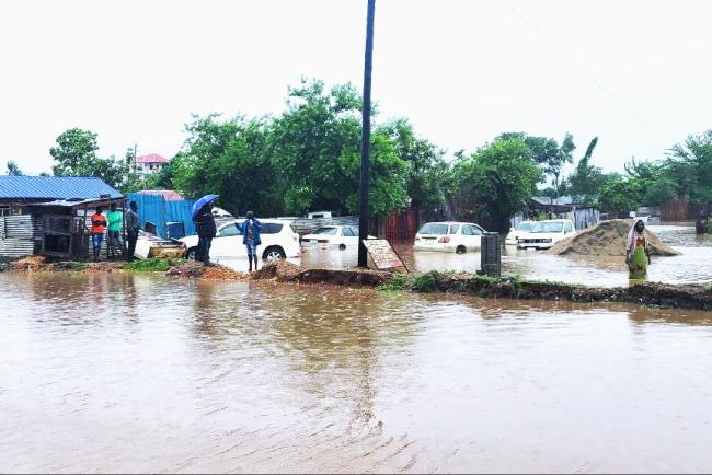
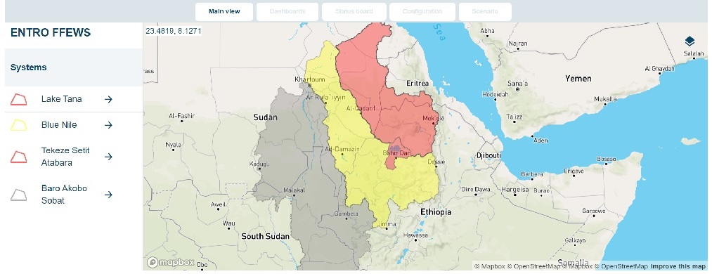
Eastern Nile Flood Forecast and Early Warning (EN-FFEW) service is a key component of ENTRO activities that has been continuously conducted every flood season (June/July through September) since 2010. The EN-FFEW activities strengthened regional collaboration through sharing of information, strengthening of national flood forecasting institutions and overall reduced the risks of flood devastation for 2.2 million people living in flood-prone areas in the Nile basins of Ethiopia, South Sudan, and Sudan. The Eastern Nile Flood Forecast Early Warning System is focusing on the riverine floods, and are conducted for Lake Tana (LT), Baro-Akobo-Sobat (BAS), Blue Nile (BN), Tekeze-Setit-Atbara (TSA) flood prone areas. The EN-FFEWS is an integrated real-time forecasting and early warning system that supports ENTRO, as well as regional and national stakeholders in flood forecasting and early warning. The EN-FFEWS has three major components: (a) meteorological forecast, (b) hydrological forecasts, and(c) flood forecasts.
Meteorological forecast: rainfall is forecasted with the Weather Research and Forecasting (WRF)1model. The model is a regional customization for the EN with global input from NCEP’s GFS to provide initial and boundary conditions. WRF produces 3-day ahead forecasts with a spatial resolution of 6 km, and the forecasts are updated daily. The temporal resolution of the rainfall forecasts is hourly. The meteorological forecast process starts with a scheduled download of NCEP’s Global Forecast System (GFS) to provide initial and boundary conditions. To ensure that the hydrological forecasts made daily, an alternatively GFS rainfall forecasts for three days lead time with one-hour time step are used – incase WRF model does not forecast. The process is automated in Mike Workbench. Furthermore: the Global Precipitation Measurement (GPM) rainfall product derived from data collected by the GPM satellite constellation with 1-day lag are used to quantify biases of the rainfall forecasts.
Hydrological forecasts: In the EN-FFEWS runoffs in the catchments of the four EN-basins and flows at key locations in the river network are forecasted with the hydrological modelling tool NAM of DHI. The inputs for forecasting runoffs in the catchments and flows at key locations in the river network come from meteorological forecasts with the WRF.
Flood forecasts: In the EN-FFEWS flood water levels at key locations in the flood prone areas in the river network of the basins are forecasted with MIKEHYDRO - River. The inputs to the hydrodynamic forecasts of flood water levels are flows from hydrological forecasts.
Integrated Forecast System: The MIKE Operations platform integrates the meteorological, hydrological and flood forecast operations. Near-real-time and forecasted data are regularly imported to the central database (Postgres SQL) through scheduled data import jobs. The rainfall-runoff and hydrodynamic models have been integrated in MIKE Operations Web so that simulation runs are triggered from the platform. The input timeseries are regularly updated using the real-time and forecasted data.
The NAM rainfall-runoff models and the MIKEHYDRO - River hydrodynamic models for the 4 basins of the EN run every 24 hours (after rainfall forecast is completed at 7:00 am EAT). When a model run is completed, results are displayed in real-time in MIKE Operations Web. If simulated or observed water level values exceed pre-defined threshold values (if available), warning triggers.
Thorough the above system the Eastern Nile Flood Forecast Early Warning System is giving Daily Flood Forecast for 77 Catchment rainfall, 44 River flow and 44 Water levels at forecast locations at the flood prone areas of the Eastern Nile part of Ethiopia, South Sudan and Sudan in the following order:
• Baro Akobo Sobat model
• Blue Nile model
• Tekeze Setit Atabara model
• Lake Tana model until the End of Rainy season.
Detail of Forecast can be found in the link below:-
https://entro-ffews-dev.westeurope.cloudapp.azure.com/