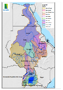
Major Subbasins
The Nile River flows through eleven countries (Burundi, DRCongo, Egypt, Ethiopia, Eritrea, Kenya, Rwanda, South Sudan,Sudan, Tanzania, and Uganda). The Nile basin comprises two broad sub-systems, these are the Eastern Nile sub-system and the Equatorial Nile sub-system. The basin was delineated into ten sub-basins (Main Nile, Atbara, Blue Nile, White Nile, Baro-Akobo-Sobat, Bahr El Jebel, Bahr El Ghazal, Lake Albert, Victoria Nile, Lake Victoria). These sub-basins featured five broad physiographic regions with diverse topography, drainage patterns and geomorphology. These physiographic regions include (1) highlands – plateaus and mountains; (2) open water surfaces (lakes – both natural and man-made); (3) wetlands and swamps; (4) flat lands; and (5) deserts. Each physiographic region has a more or less uniquecombination of surface, slope, soils, topography and vegetation. The first two physiographic regions mainly in the upper subbasin, and the later three regions covers mostly the mid and lower sub- basins.The Nile River is the longest river in the world at 6,695 km, flowing northward through the tropics and the highlands of eastern Africa and drains into the Mediterranean Sea. The basin covers about one-tenth of the area of the continent, drains a total land area of 3,176,541 km2. Beside its length, the Nile River basin contains other unique features among the world large river basins, e.g. the Sudd wetland, Lake Victoria; 17 wetlands sites registered by Ramsar and diverse species of flora and fauna.
Download
Major%20Subbasins_0.pdf3.4 MB
