

Flooding is an annual problem in many countries in the Nile Basin including Sudan and Uganda. August and September in the Eastern Nile region are especially dangerous months because the Monsoon rains pour in the Ethiopian highlands and flow down to the Blue Nile and White Nile, causing untold havoc as the waters flood the lower lands in Sudan. After hours of heavy rains, there is usually bursting of river banks, which go on to submerge neighbouring communities while destroying lives and crops. Drought usually accompanies floods after crops have been destroyed leaving nothing behind for communities to feed on.
The Eastern Nile Technical Regional Office (ENTRO) started the Flood and Drought Risk Mitigation (FDRM) project to contribute to the improved mechanisms for cooperation on water resources management and development in the Nile Basin. The FDRM is under the Component 3 (Improving Mechanisms for Cooperation in the Eastern Nile) of the Nile Cooperation for Climate Resilience (NCCR) project financed by the Cooperation in International Waters in Africa (CIWA) - World Bank over the period (2021-2025). ENTRO is leading the project while the NBI Secretariat, NELSAP and the Nile Basin Discourse (NBD) participate in the sub-project.
The specific objectives are to enhance services for preparedness against flood and drought risks through provisions of flood and drought forecasting on regional and basin wide platform, and to contribute to enhanced national/regional capacities to accommodate the impact of climate variability as related to flood & drought for climate-resilient water resources management.
The Flood and Drought Risk Mitigation project is aligned with ENTRO's 3rd Strategic Plan (2018-2022): “Promoting Cooperative Transboundary Water Resource Planning and Management - Improve Eastern Nile Countries' Preparedness for Flood and Drought Risks”. It is linked with the NBI 10-Year-Strategy 2017-2027 of Goal 5, which is to “improve basin resilience to climate change impacts”.
In March 2001, the Eastern Nile Council of Ministers (ENCOM) requested that funding be sought to advance work in flood management. In October 2004, ENCOM decided to fast-track the Flood Preparedness and Early Warning (FPEW) project to show tangible results of Ni...
Flood Forecasting and Early Warning
In March 2001, the Eastern Nile Council of Ministers (ENCOM) requested that funding be sought to advance work in flood management. In October 2004, ENCOM decided to fast-track the Flood Preparedness and Early Warning (FPEW) project to show tangible results of Nile Basin collaboration on the ground.
In 2006 it was decided that implementation of the Flood Preparedness and Early Warning Project (FPEW) would be done in two phases, with the first phase – FPEW I – focused on building the institutional capacity and developing critical baseline information to enhance the readiness of EN countries to implement subsequent FPEW phases. The second phase – FPEW II – focuses on the structural measures and up-scaling of the pilot interventions in Lake Tana (Ethiopia) and Tuti Island (Sudan).
FPEW Phase I was successfully completed in 2010, delivering a platform for institutional settings and data/information collections/sharing at community and national levels, together with enhancing regional coordination and cooperation with the recommendation for the follow-on the subsequent phases (FPEW phase II).
The proposal of FPEW II has evolved from national and regional consultations to focus on the structural measures and up-scaling of the pilot interventions. This proposal was finalised in 2007 and distributed to different stakeholders and donors to secure funding. Tho...
Flood Preparedness and Early Warning (Phase II)
The proposal of FPEW II has evolved from national and regional consultations to focus on the structural measures and up-scaling of the pilot interventions. This proposal was finalised in 2007 and distributed to different stakeholders and donors to secure funding. Though funding was not secured to work on FPEW II, after the completion of FPEW I project, ENTRO initiated with Eastern Nile countries and created a regional Flood Forecast and Early Warning (FFEW) system under the Eastern Nile Planning Model project (ENPM) and the FFEW activity has resumed under the current Nile Cooperation for Result project (NCORE).
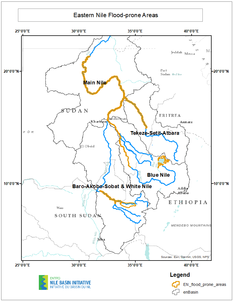
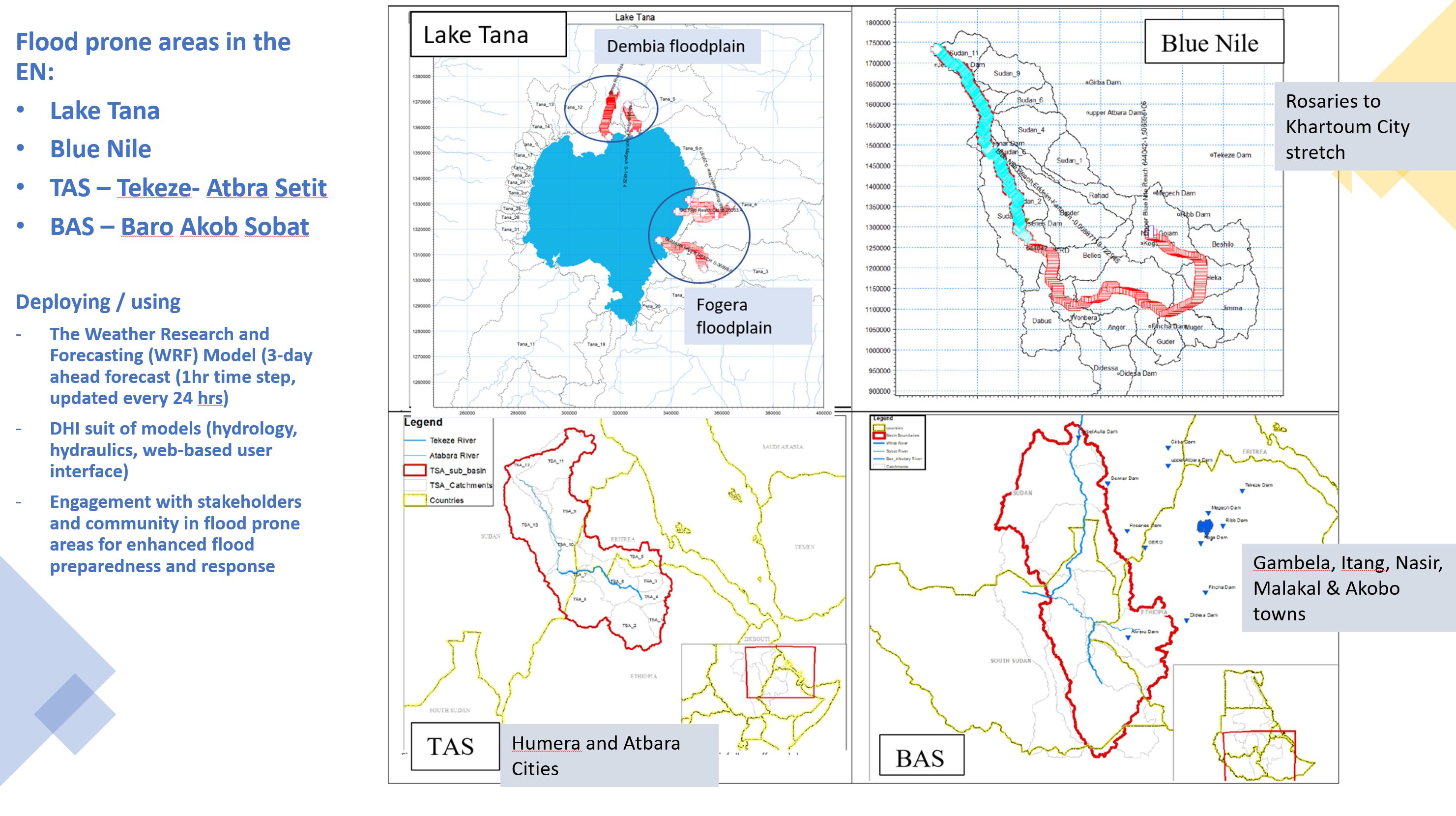
The FFEW, since its establishment, has been an important part of ENTRO’s activity that continuously been conducted since 2010 for every flood season (June-September). The FFEW has helped the Eastern Nile countries in reducing the loss of lives and money by preparing flood forecast bulletins for the Lake Tana (Blue Nile-Ethiopia), the Blue Nile-Main Nile (Sudan) and Baro-Akobo-Sobat (BAS) sub-basins flood prone areas. The FFEW activity have strengthened national offices in terms of capacity and overall reduced the risk of flood devastation for 2.2 million people in the region. Reports on EN-FFEW system can be found in https://entrospace.nilebasin.org/
This is customized for the Easter Nile of the Weather Research and Forecasting (WRF) model. The model is a regional customisation for the Easter Nile countries with global input from NCEP’s GFS to provide initial and boundary conditions. WRF produces three-day f...
Meteorological Forecast
This is customized for the Easter Nile of the Weather Research and Forecasting (WRF) model. The model is a regional customisation for the Easter Nile countries with global input from NCEP’s GFS to provide initial and boundary conditions. WRF produces three-day forecasts with a spatial resolution of 6km, and the forecasts are updated daily. The temporal resolution of the rainfall forecasts is hourly.
Three-day forecasts of flood hydrograph using the hydrological forecasted rainfall are made for the four Easter Nile basins and results are generated at key flood prone locations in the river network using NAM of DHI. NAM simulates the terrestrial phase of the hydrol...
Hydrological Forecast
Three-day forecasts of flood hydrograph using the hydrological forecasted rainfall are made for the four Easter Nile basins and results are generated at key flood prone locations in the river network using NAM of DHI. NAM simulates the terrestrial phase of the hydrological cycle. It allows developing deterministic and lumped hydrological catchment-based models.
Water levels at key locations in the flood prone areas in the river network of the basins are forecasted with MIKE 11, which is built based on the existing ENTRO HEC-RAS flood inundation model. Observed flow and gauge levels, where available, are used for calibration...
Flood Forecasts
Water levels at key locations in the flood prone areas in the river network of the basins are forecasted with MIKE 11, which is built based on the existing ENTRO HEC-RAS flood inundation model. Observed flow and gauge levels, where available, are used for calibration. To date there is no telemetric real-time data that can be used for the data assimilation, however, there are manual flow gauges at limited locations that report on a daily basis. An effort will be made to develop a mechanism for these gauges to report to the central database, and the data to be used for data assimilation duing flood season.
The three components (Meteorological Forecast, Hydrological Forecast and Flood Forecasts) were setup in the MIKE Operations platform whose purpose is to integrate operation and planning tools or models with near-real-time, forecasted and historical observed data...
Integrated Forecasting System
The three components (Meteorological Forecast, Hydrological Forecast and Flood Forecasts) were setup in the MIKE Operations platform whose purpose is to integrate operation and planning tools or models with near-real-time, forecasted and historical observed data.
Generally, the focus of the Flood Risk Mitigation project is to strengthen preparedness for riverine flood by building capacity on innovative tools through the installation of early warning systems, risk assessment, improving forecasting capacity, strengthening human...
Flood Risk Mitigation Main Activities
Generally, the focus of the Flood Risk Mitigation project is to strengthen preparedness for riverine flood by building capacity on innovative tools through the installation of early warning systems, risk assessment, improving forecasting capacity, strengthening human and institutional capacity. These efforts will be complemented with increasing capacity for data analysis and processing, strengthening the regional knowledge base and packaging as well as national and regional level trainings on different forecasting tools.
With this, ENTRO envisages to enhance riverine Flood Forecast and Early Warning System for the Eastern Nile region through three services:
- Work Package 1: Survey and Data Collection
- Work Package 2: Enhancement of the Eastern Nile Flood Forecasting and Early Warning System (EN-FFEWS) and Flood Risk Mapping
- Work Package 3: Support in Establishing Flood Community Awareness and Preparedness
Droughts have severe impacts on societies, economies, agriculture and ecosystems. The Nile basin is known for some of the most extreme droughts in recent history with devastating consequences to the region. Successive years of low and erratic rainfall have left large...
Drought Risk Mitigation
Droughts have severe impacts on societies, economies, agriculture and ecosystems. The Nile basin is known for some of the most extreme droughts in recent history with devastating consequences to the region. Successive years of low and erratic rainfall have left large areas of the basin in severe drought that result in crop failure, low or dry rivers, less water storage and have raised serious food security problems in the region. The period from 1950 to 1988 saw 18 droughts, some leading to serious famines leading to thousands of death in Ethiopia, the worst was during 1984-88. Ethiopia also faced a devastating drought in late 2015, largely caused by an El Nino.
Historically, deaths and famine have followed the lack of water for irrigation that badly affected agriculture. In 1913-14, for instance, Egypt suffered one of its worst droughts in recorded history, while dry years in 1979-84 coincided with the drought in the Sahel that extended to Ethiopia and Sudan. Recent historic droughts affecting millions of people in Sudan were in 1886, 1913, 1940, 1967-1973, and 1980-1984, and 2011-12. Lake Victoria region of Kenya experienced severe drought in 1983–1984, 1980, 1975, and 1971. In Uganda, severe droughts occurred in 1967, 1979, 1987, 1999, 2010 and 2017. Recently, Tanzania experienced severe drought in 1999/2000 which extended to 2005, and in 2010/11.
In addition to the natural climate variability, increased vulnerability due to climate change impacts and rising populations in the Eastern Nile countries demonstrates a strong and urgent need for drought monitoring, forecasting and the associated analysis tools that could strengthen decision support. Forward planning is critical for managing the impacts of drought, since early action enables stakeholders, such as governments, rainfed farmers, pastoralists, public water supply, hydropower, and agricultural companies, to select drought resistance seeds, strategically collect and locate cattle feed and water, curb demand and to effectively manage diminishing water resources / occasional rainfalls. Improved forecasts on drought management (monthly to seasonal) and planning timescales (seasonal to decadal) would be exceptionally valuable for effective drought management and for minimizing the negative impacts of droughts.
Many researchers and practitioners note that droughts are complex events, with impacts dependent on meteorological, hydrological and land surface factors as well as on water demand and management. Consequently, drought assessment and forecasting (based on rainfa...
Types of Drought
Many researchers and practitioners note that droughts are complex events, with impacts dependent on meteorological, hydrological and land surface factors as well as on water demand and management. Consequently, drought assessment and forecasting (based on rainfall, streamflow and soil moisture forecast) has many components: forecasting the main drought driver that is the forecasting of meteorological drought (deficit of rainfall), then forecasting agricultural drought (soil moisture deficit, NDVI) and forecasting hydrological drought (decline in surface water and groundwater), and finally forecasting the consequences of drought for water availability, socioeconomic and forecasting the effects of drought management. All these forecasts are uncertain and any improvement in decision-making needs to consider all aspects of the forecast process.
Currently two drought forecasting systems are being developed at NBI. These incudes (a) a seasonal drought monitoring, forecasting, and early warning system, that provides seasonal hydrological and meteorological drought forecast for the Eastern Nile basin developed ...
Existing Drought Forecasting Systems in NBI
Currently two drought forecasting systems are being developed at NBI. These incudes (a) a seasonal drought monitoring, forecasting, and early warning system, that provides seasonal hydrological and meteorological drought forecast for the Eastern Nile basin developed by Princeton Climate Analytics (PCA) and (b) the DHI drought forecasting system (using satellite imagery used to monitor precipitation, soil moisture, and vegetation health to support drought early warning systems) piloted for the Nile basin.
The main gap of these two systems is the spatial coverage which is limited only for the Eastern Nile part and with few selected indices. Thus, this project will conduct an evaluation of both systems and assess the suitability for Nile basin to be upscaled and consistency of the system for future sustainability. The proposed activities will advance the overall effort of monitoring and forecasting of droughts by improving resolutions; providing localized data; packaging information; disseminate for wider stakeholder and enhance technical capability.